The Russian ship, the cable and... the mineral deposit
This article is also available in French.
Today, for a change from cyber (although we will be talking about AI, data and bias), I suggest you grab a bag of popcorn and settle in comfortably. We are going to talk about a film. More precisely, about two scenarios. Tempted? Off we go.
Two scenarios for a good film, then, with espionage and high-seas operations in the background but, in the end, a single story (and it ends well).
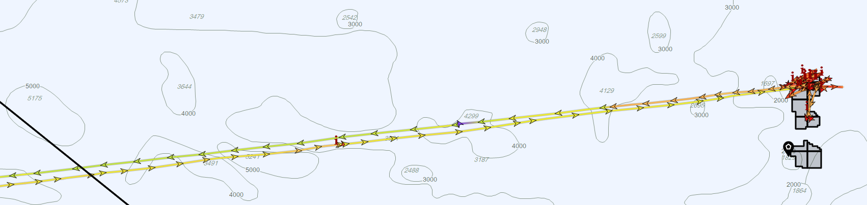
First scenario. A Russian ship, managed by a company under US sanctions, moving slowly in the middle of the Atlantic Ocean, about 1,600 kilometres (860 NM) east of Barbados, and staying there for 41 days. No port call, apparently no other ship encountered, its AIS transponder on the whole time, and, according to some submarine cable maps, a piece of “critical” underwater infrastructure nearby. Calling it a spy ship is only one step further, a step easily taken if you do not stand back.
Second scenario. The same ship, on the same dates and in the same position, running a prospecting campaign across a metallic sulphide deposit, with the fairly irregular kinematics typical of that kind of operation, inside mining blocks allocated to Russia by the International Seabed Authority, 305 kilometres (165 NM) from the nearest cable.
The first scenario is made for social media: it fits in a screenshot, it confirms an anxiety that is already in place, and it can be shared in twenty seconds. The second has no place there, because you have to go and find a mining data layer, then strain your eyes on nautical charts to work out the slightly more precise position of the cables said to be “nearby”.
Yet both scenarios rest on exactly the same data. Only the reading changes. The first comes out of a chain of AI algorithms trained to spot what departs from a ship’s expected behaviour. It did its job, since this behaviour does depart from it. What it could not know, having never been fed that kind of data, is what lies on the seabed at that spot, and what permissions have been granted there. That is where the human being shows their modest usefulness, and has to bring critical judgement and perspective.
Why the first reading holds up
There is nothing absurd about that first version, and that is precisely the problem. The behaviours described are real: the ship stayed 41 days on station, at very low speed, and its manager is indeed on the US sanctions list. The concern about cables is potentially well founded, the Baltic Sea precedents being documented, even if those involved merchant ships attached to the shadow fleet rather than oceanographic research vessels.
Depth, however, changes everything. The Baltic averages some sixty metres deep and the Gulf of Finland barely exceeds 120 metres: a merchant ship’s anchor reaches the bottom there and can snag a cable, by accident as much as by design. Here, the seabed is 2,500 metres down. No anchor goes that deep, and any intervention requires a remotely operated vehicle launched from a ship equipped for it, a rare, expensive and identifiable capability. The background on what these systems carry is in the article on submarine cables.
Three questions were left unanswered, too. Why send a ship thousands of kilometres for a single cable? Why that particular cable linking Brazil to the United States? And why at that precise point, when the cable is potentially more “exploitable” elsewhere?
Those questions are what had me spending a few late evenings in front of my screens, searching, identifying, cross-checking, thinking about an alternative possibility.
Finding this ship, without being given its name
But before starting any analysis, the ship had to be found, of course. The usual identifiers, name and IMO number, were not given in the sponsored article in question. That left the characteristics: 82 metres, 36 years old, Russian flag, listed sometimes as an oceanographic research vessel and sometimes as an offshore support vessel depending on the database, a Panama Canal transit on 16 February 2026, a registered Cypriot owner acting for a Russian company sanctioned since February 2023.
Three steps are enough, in any reasonably serious ship database.
- Filtering on those criteria, with a length range of 78 to 88 metres since databases do not agree to the metre, leaves a few dozen hulls.
- The voyage history of those whose last known position is in the Russian Far East, cross-checked with a Panama Canal transit outbound in mid-February and inbound in early May, leaves only one.
- Checking the management structure settles it.
The public data on the ship then gives far more precise information than the publisher’s public note: the Panama Canal transit on 16 February, the return on 3 May, and a manager designated by OFAC on 24 February 2023, which the SDN list search engine confirms in a single query [1].
I am not naming this ship. As we will see below, it was working in an area Russia appears to be authorised to explore, and nothing requires publicly attaching the name of a ship and its crew to a story about espionage, even in order to refute it. The method is above, and it matters more than the name: a verification nobody can reproduce is worth as little as the claim it disputes.
Two kinematics that look like anomalies
Before reaching the area, two episodes were flagged by the AI as unusual behaviour.
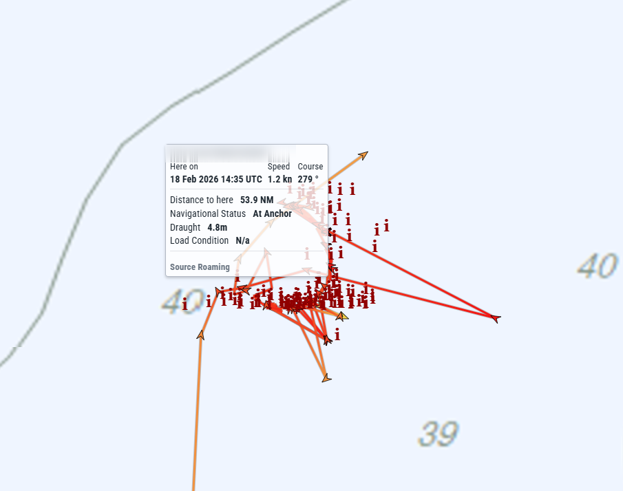
First “anomaly”: forty-eight hours of erratic track in February, which could have suggested position falsification. In fact, the ship was in a designated anchorage area outside Colón, at the Atlantic entrance to the Panama Canal, in 40 metres of water, surrounded by other waiting ships. The canal’s operating rules define several waiting areas there and set the conditions for anchoring [2]. The arc of a circle and the tight clusters of positions are what is called swinging at anchor. Put simply: a ship at anchor pivots around its anchor with the tide, the wind and the current. The figure changes from one anchorage to another, since those three factors change too, but the mechanism is the same everywhere and the arc it draws is recognisable. This reading is not a matter of interpretation: a team from the University of the West Indies validated it by diving, finding the anchor point on the seabed within ten metres of the position derived from AIS, and the chain length within five metres [3].
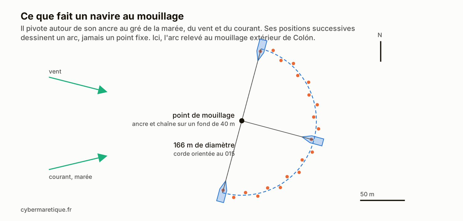
The navigational status field, which the crew fills in by hand, read “at anchor” throughout the sequence, with a residual speed of 1.2 knots. If you like details, the arc measures 166 metres across in 40 metres of water, which matches the chain length paid out in such conditions. The exact figure hardly matters: what counts is that the track describes a circle of roughly constant radius around a fixed point, which a drifting ship never does. Two consistent and independent elements, the geometric figure and the declared field, are worth more than one. Add a matter of plain common sense: you do not anchor wherever you please at the entrance to a canal. The ship was necessarily under the watch of the Vessel Traffic Services (VTS), which assigns the waiting areas and authorises anchoring, and it was surrounded by dozens of other ships. It is hard to picture a clandestine operation, or a position falsification, carried out for forty-eight hours under the eyes and the radar of the canal authority and of all those neighbours.
As for verifying the AI’s work, it took a single move: capturing the kinematics of the neighbouring ships at anchor, which were drawing very similar figures at the same moment. The bias probably came from a “default” filter on the ship’s country.
Second “anomaly”: two series of geometric figures, squares and lines run in both directions along the same axis, one off the Antilles, in 320 metres of water on the Aves Ridge, the other further south, in 150 metres on the Tobago shelf. That series of figures could correspond to the calibration of a multibeam echosounder [4], to the calibration of an acoustic positioning system [5], or to other checks, of dynamic positioning for instance. That would be consistent with a ship checking its equipment before going to work deeper. In any case, no critical infrastructure nearby.
So what was it doing out there?
With those two episodes behind it, the ship arrives on station. The International Seabed Authority allocates mining exploration areas on the high seas and publishes their geometry [6]. Russia has held a polymetallic sulphide prospecting contract there since October 2012, on the Mid-Atlantic Ridge, originally divided into a hundred or so blocks 10 kilometres on a side, of which 56 remain active in the Authority’s geographic register [7]. And it is not alone on that ridge, which is a chequerboard of concessions: 277 polymetallic sulphide blocks are allocated there, shared between France (100 blocks), Poland (100) and Russia (77), following one another from south to north between 13 and 33 degrees of northern latitude.
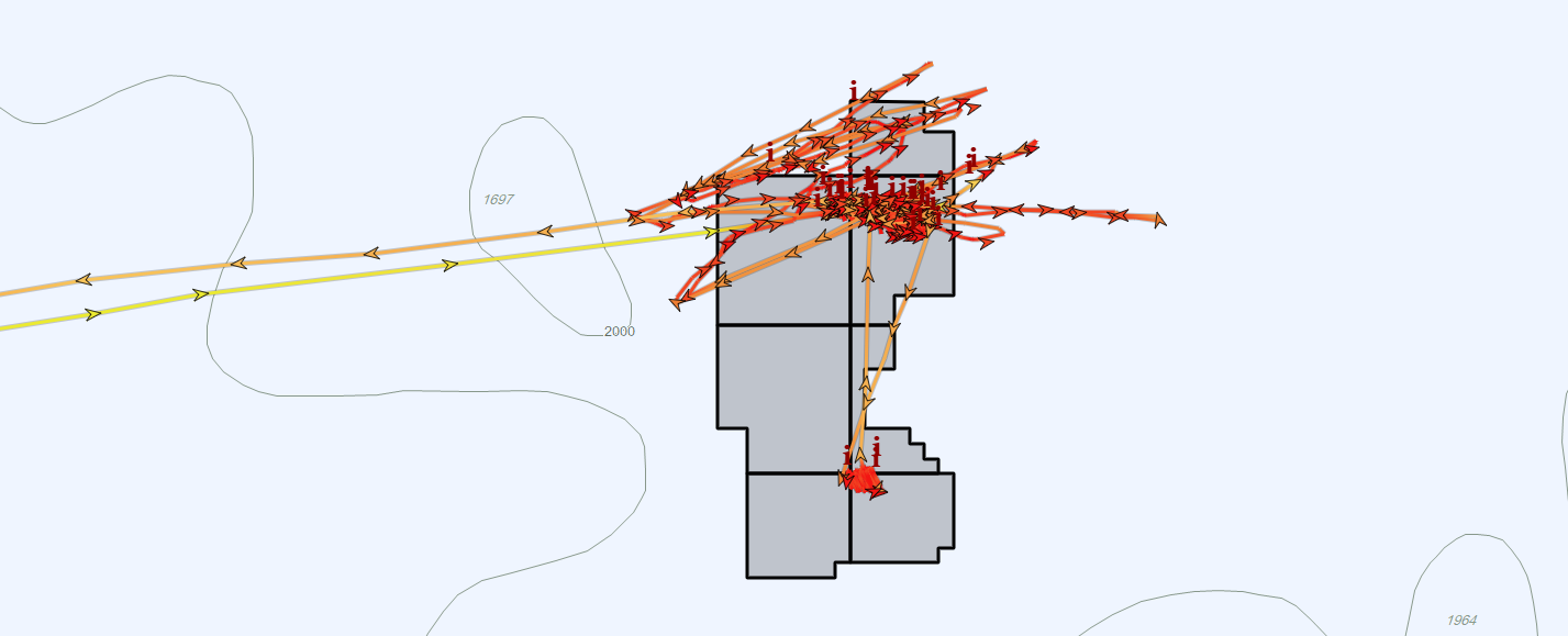
The contract holder is the Russian state, and nothing in the public sources formally links this ship to that holder: the connection remains an inference, based on the flag, on the manager’s line of business and on the position. Cross-checking the ship’s kinematics with those areas shows that it works most of the time in a single block under contract, then in a second one at the end of the period. The 24 March fix falls in the portion of that block Russia has relinquished to the Authority, and a single one, on 14 April, lies outside any area, 83 kilometres (45 NM) further east. The check covered the 4,500 areas in the register, all contractors and all statuses combined.
Beneath those blocks lies the Semenov hydrothermal field, a dome elongated east to west, 10 kilometres long by 4.5 wide, in about 2,500 metres of water, which is the size of the box the ship covered for 41 days [8].
Above all, this deposit was discovered in 2007 by the Russians themselves, five years before they obtained the contract. As early as June 2007, the Russian geological service documented a first deep sulphide prospecting campaign along the axis of the ridge and on the neighbouring Ashadze field, run by the polar marine geological prospecting expedition aboard a research vessel [9]. What we are seeing in 2026 is therefore not a sudden appearance, but one more campaign in a programme that has been running for 19 years.
Cable or no cable?
That leaves the question of the cable, and it is settled by the quality of the sources. The routes published online are convenience polylines: one of the systems crossing this area, more than 10,000 kilometres long, is made of 22 vertices, only four of them for the whole deep-water leg between Brazil and Florida [10]. A string stretched between two vertices 1,100 kilometres (600 NM) apart passes where the geometry takes it, not where the cable is laid. Suffice it to say that this geometric route is not representative of the real position of the cable on the seabed. And that is normal, because the precise routing of cables is generally not public information. The most precise source remains the nautical chart, well ahead of the neat straight lines of open sources.
Looking at nautical charts, the most precise ones available, the cable closest to the working area passes 305 kilometres (165 NM) away, in more than 4,000 metres of water.
That gap is explained by geology. The engineers who drew those routes knew what they were doing: a cable skirts the axis of the ridge, whose rugged relief, volcanism and seismicity are exactly what a cable ship seeks to avoid. Yet that is where, and only where, polymetallic sulphides form, and therefore where the Authority allocates its blocks. A cable and a ridge deposit have little chance of ending up as neighbours.
Why does the alarming version always win?
The imbalance between the two scenarios is also psychological, and well known. A landmark study on the spread of false news, carried out on 126,000 stories and 3 million accounts, shows that false stories travel farther and faster than true ones, through longer sharing chains, and attributes part of the gap to their novelty and to the emotions they trigger [11]. Our case is not a piece of false news, it is a plausible and incomplete reading, but the engine of diffusion is the same. Add availability in memory: two years of severed cables in the Baltic have installed sabotage as the first accessible explanation, whereas almost nobody knows that mining areas are allocated by treaty on the high seas.
The tool adds its own bias. Research on automation calls misuse the uncritical reliance on a system whose limits and failure modes are not recognised [12]. A result put forward by an AI and by a quality company arrives with an authority the same sentence, said by a colleague, would not have, and it presents a wrong value exactly as it presents a right one.
The biases of maritime data
Any maritime analysis based on data, mine included, rests on assumptions and can be subject to bias. Here are a few of them.
- AIS relies on terrestrial and satellite sensors that are almost all private. A handful of players operate a global network, the rest of the market buys their data, recombines it and resells it, with its own assembly errors. Saying where the positions you use come from is the first of the precautions, and it is rarely taken. So let me tell you: mine come from MarineTraffic.
- Sensors and transponders aboard ships, like sensors ashore, sometimes get it wrong. Anyone who has handled large volumes of AIS data has seen unintentional quality defects on transponders, desynchronisation in analysis tools, and the rest. A poorly covered area produces gaps that the display joins with a straight line, messages can be lost, and satellite S-AIS reception is brilliant but it also has its limits at times.
- The message is declarative. A transponder can be switched off, reconfigured, and the identity it broadcasts is entered on board. Nothing indicates that this is the case here, nothing rules it out, and the caveat applies to both readings, which rest on the same track.
- AIS says nothing about what is put in the water. Mineral prospecting and cable inspection can look very much alike from above: the difference lies in reading the chart underneath and in cross-checking with more complete maritime data.
- This verification remained entirely documentary. Neither the canal authority, which assigned the anchorage and recorded the transit, nor the International Seabed Authority, which receives annual reports from its contractors, nor the ships in the vicinity were contacted. An email or a phone call could have confirmed or disproved several elements in a single answer, and the remark applies as much to the reading being disputed as to my own.
- We only analyse what we have noticed, or what we are focusing on. We then forget to check the kinematics of the ships that were waiting at anchor for a transit slot, or carrying out repairs.
And I am certainly forgetting some.
I am not openly criticising these AI-based analysis platforms. What I am trying to show is that the “raw” reading and publication of an anomaly detected by an AI on a ship “of interest” should not be enough, on its own, for that kind of qualification, and that work remains to be done on these algorithms to improve them. The human eye and a seafarer’s experience have something to bring here: a complementary analysis, which in this case would probably qualify the event as a false positive, and the means to train the AI better, with the kinematics of swinging at anchor and with mining exploration and exploitation areas. And this is not the only case of loitering reported on social media that could turn out to be a false positive. But the analysis time it would take each time is too long for an independent analyst.
So, espionage or mineral prospecting?
None of the above establishes that the deployment was harmless. The manager is indeed under sanctions, and a research vessel equipped for the deep ocean could map a mineral deposit and a piece of infrastructure just the same. Those elements justify continuing to follow this ship.
That said, it is also worth noting that the ship’s AIS transponder stayed on for 41 days in a row. Would a ship sent to deal with a submarine cable not have every reason to switch off its transponder, and the means to do so, rather than let itself be followed position by position by anyone with a subscription to a tracking platform? Broadcasting continuously above its working area, for six weeks, would rather be the behaviour of an operator with nothing to hide about where it is.
None of the above targets a publisher, but a chain of reasoning that is met regularly in this market. The exercise has precedents on this blog, and they look alike: waiting for the facts before drawing conclusions after a collision attributed too quickly to spoofing. The literature on correcting a piece of wrong information fits in some thirty pages: start with the fact rather than with the rumour, explain the mechanism that produced the error, offer a replacement explanation, and never leave the reader with a gap to fill [13].
A final word to clear up a predictable misunderstanding: nothing in the above defends anyone. Russia, like other countries, is equipped to conduct operations near underwater infrastructure, and there is no doubt that it does. This article does not say otherwise. What is examined here is a chain of reasoning, not a flag. It would produce the same gap applied to a Chinese, American or French ship, and I would have written it the same way. A reader who took from it a blank cheque for the Russian fleet, or a charge against those who raise the alarm about cables, would be wrong on both counts.
Right of reply
Any person or organisation who considers themselves implicated by this text has a right of reply. A request sent through the contact page will be published in full and without comment following this article. Factual corrections are welcome and will be made with the change flagged.
Sources
- [1] Office of Foreign Assets Control, SDN list search engine
- [2] Panama Canal Authority, advisory N02-2025, “Harbor Operations”, waiting areas and anchoring conditions at Cristóbal and Balboa
- [3] Marissa Small and Hazel A. Oxenford, “Low-cost, high-resolution method for determining cruise ship anchoring behaviour”, Frontiers in Conservation Science, 19 September 2025, DOI 10.3389/fcosc.2025.1552357
- [4] NOAA Ocean Exploration, “Multibeam Calibration: Conducting a Patch Test”
- [5] NOAA Ocean Exploration, “Deepwater Exploration Mapping Procedures Manual” (2020)
- [6] International Seabed Authority, maps and geographic layers of the exploration areas
- [7] International Seabed Authority, exploration contracts for polymetallic sulphides
- [8] Mineralium Deposita, “Fe-oxyhydroxide deposits at Semenov hydrothermal field (13°30’N), Mid-Atlantic ridge” (2025)
- [9] Rosnedra, “Marine geological work in the central Atlantic” (4 June 2007), first stage of deep sulphide prospecting by the polar marine geological prospecting expedition
- [10] TeleGeography, Submarine Cable Map, public routes of the transatlantic systems
- [11] Soroush Vosoughi, Deb Roy and Sinan Aral, “The spread of true and false news online”, Science, 9 March 2018, DOI 10.1126/science.aap9559
- [12] Raja Parasuraman and Victor Riley, “Humans and Automation: Use, Misuse, Disuse, Abuse”, Human Factors, 1997, DOI 10.1518/001872097778543886
- [13] Stephan Lewandowsky, John Cook et al., “The Debunking Handbook 2020”, DOI 10.17910/b7.1182
